Digital Mapping Service

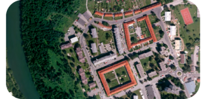
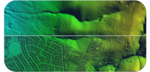
ScanMap produces high precision digital maps and geo-data from aerial/UAV stereo images for private and public enterprises who want structured data concerning landscapes, infrastructure and features related to buildings. The global delivery center process and distribute data by means of the newest technologies of photogrammetry.

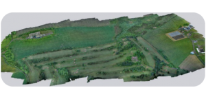
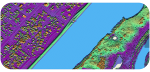
ScanMap also produces high precision digital models and geo-data from Airborne/UAV/Laser Scanning, Bathymetric Data and Ortho images for clientele who want structured data concerning landscapes, infrastructure and features related to Earth Surface. The offshore production center process and distribute data by means of the newest technologies of Geographic Information System (GIS).

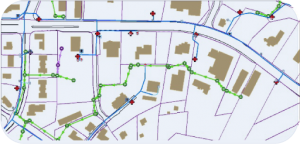
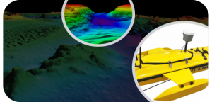
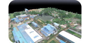
ScanMap serves with one stop, complete, stat-of-art mapping & modeling solutions from planning, acquisition of aerial photography & laser scanning, aerial triangulation, raster & vector and 3D city modeling for any purpose.

With clientele from Europe and America , we know what the westerns look forward to. Right job at right time at a competitive cost is our commitment.

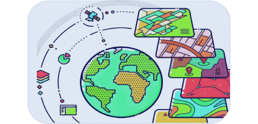
GSI is an integral part of today’s information systems

GIS delivers real value when integrated with traditional enterprise business data and applications to solve real-world problems. Location, as a primary element of corporate databases, permeates enterprise IT systems in human resources, finance, marketing, and logistics. GIS technology weaves together and integrates disparate business systems using location as the common factor.

SCANMAP leverages GIS information within dynamic business processes. We can spatially enable your existing or planned business applications such as Enterprise Resource Planning, Customer Relationship Management, Asset Management, Maintenance Management, and Human Resource Systems. Our extensive GIS implementation experience ensures that the solutions we implement are future-proof.

By integrating GIS with traditional IT applications, existing work-flows, and back-end systems, we ensure that geospatial information is consistently available, useful, relevant, and ready to deliver economic value to your organization.

GIS-enable your organization

ScanMap is a professional services company specializing in the development of intelligent, enterprise wide geo-spatial data solutions for clients in a variety of disciplines and industries. It has different groups providing a variety of services for customers.

GIS Consulting

The consulting services address every phase of the GIS life cycle to offer solutions within a variety of different application areas. ScanMap’s team of experienced GIS professionals supports needs assessment, database design, system architecture design, implementation planning, and project management.

Geospatial Database

This includes geodatabase design, data automation, data conversion, and quality assurance services. ScanMap has extensive experience in CAD to GIS data conversion and ensures that high-quality data is made available to the GIS application.


 Its data conversion procedures include automated creation of feature connectivity, recognition of closed areas, reconciliation of discrepancies, error detection & reporting, and validation of exported data to the specific

UAV Surveying & Data Processing

Remotely Piloted Aerial Systems (RPAS) are being used more extensively across a range of disciplines, including the field of surveying.

The UAV Surveys Aircraft are commonly referred to as Drones, Unmanned Aerial Vehicles (UAVs) or Remotely Piloted Aircraft (RPA) with the combination of operating equipment (including the aircraft, the control station and the data link) referred to as either Unmanned Aerial/Aircraft System (UAS) or Remotely Piloted Aerial Systems (RPAS).

Orthophoto Production

Orthophoto production is one the most important services by ScanMap.

Orthophoto Production

We have successfully completed several Orthophoto projects for its clients from Europe. ScanMap provide the final output of orthophoto with proper radiometric and geometric corrections. We have highly trained and efficient Photogrammetrists with well configured workstations and software to ensure smooth production.

Orthophoto Production

ScanMap is extending its digital orthophoto production capabilities to ensure the requirement of high-end mapping requirements with emphasis on geometric quality, color balance, edge matching etc. Our highly skilled operators, trained in Denmark, can handle very large orthophoto projects with emphasis on time and quality.

Vector Mapping

Vector mapping from aerial stereo images/GTS Survey data is one of the most important services by ScanMap. We have successfully completed several vector mapping projects for its clients from Europe and USA.

Vector Mapping

Vector mapping projects involves new mapping as well as updating of existing data.

Usually these kinds of mapping are based on different specifications from clients, for example, TK99, DGP, FOT etc (Danish mapping specification) where our highly trained operators are experienced.
 
ScanMap also provides thematic mapping services in applications such as Land use /Land cover mapping, vegetation cover mapping, soil mapping, drainage mapping, and geological mapping.

LiDAR Data Processing

Digital Terrain Model (DTM) and Digital Surface Model (DSM) from Airborne/UAV Laser Scanning Data Processing is one of the most important services by ScanMap. We have successfully completed several DTM and DSM projects for the clients from Europe.

LiDAR Data Processing

DTM and DSM involve new modeling as well as updating of existing data. Usually these kinds of modeling are based on different specifications from clients where our highly trained Analyst are experienced at ScanMap.

DTM

Airborne/UAV Laser Scanning data, Ortho Images as Background Reference file, Mapping Specification.

Bathymetric Survey & Mapping

ScanMap process highly precise Unmanned Surface Vehicle (USV) survey data for Hydrographic mapping. We provide under water earth surface DTM and DSM superimposed with river/ocean vector map, which involve new modeling as well as updating of existing data. Usually these kinds of modeling are based on different specifications from clients where our highly trained Analyst are involved.

Bathymetric Survey & Mapping

3d Building Model

3D City Model is one of the highly pronounced products now a days in the filed of Photogrammetry and Geo-information. SML is trained at production high quality & high detail 3D buildings from stereo images.

3d Building Model

3D City Model is one of the highly pronounced products now a days in the filed of Photogrammetry and Geo-information.

ScanMap is trained at production high quality & high detail 3D buildings from stereo images.

Level of detail (LOD) for 3D buildings varies depending on projects requirements; usually it is very high in city center where buildings are pretty complex, and low in single family house plots or country areas where buildings are simpler.

3d Building Model

Our Clients

Driving technology for leading brands
Danish Geodata Agency
State of Alaska
Copenhagen Municipality
Stockholms stad
Ministry of Environment and Food of Denmark
Robi
Airtel

DO YOU WANT TO...

Take some time to fill out our contact form

See our other products and services.